Moving On

Adventures in the West, plus other topics

Monday, August 28, 2006

Glenwood Canyon, for the weak & attentive


About 90 miles east of Grand Junction on I-70 is the town of Glenwood Springs and Glenwood Canyon. I knew I was going on a bike outing to this area a few weeks ahead of time, so I bought a mountain bike at WalMart. WalMart?? The bike has a welded aluminum frame, Shimano indexing shifters, disc brake on the front and a full front and rear suspension. Even with all these goodies, I had enough left over to buy a large soft replacement bicycle seat for my large soft posterior. I rode it for a few weeks to get comfortable and I was ready for Glenwood Canyon. Actually, Glenwood is easy enough that advance preparation is not necessary. A good description of this bicycle tour can be found at:
http://www.wildernet.com/pages/activity.cfm?actid=021504IO*19hw&CU_ID=1

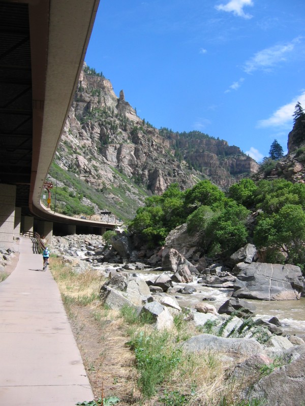
Our group started at Grizzly Creek. We could have started at an exit called "No Name", yes, that's really the name of the exit, but there is a hill between No Name and Grizzly, so we started at Grizzly. There is a large parking lot and a good restroom there.

We rode in the upstream direction, along a sidewalk, taking in the sights, like rafters.


And kayakers practicing their Eskimo rolls.


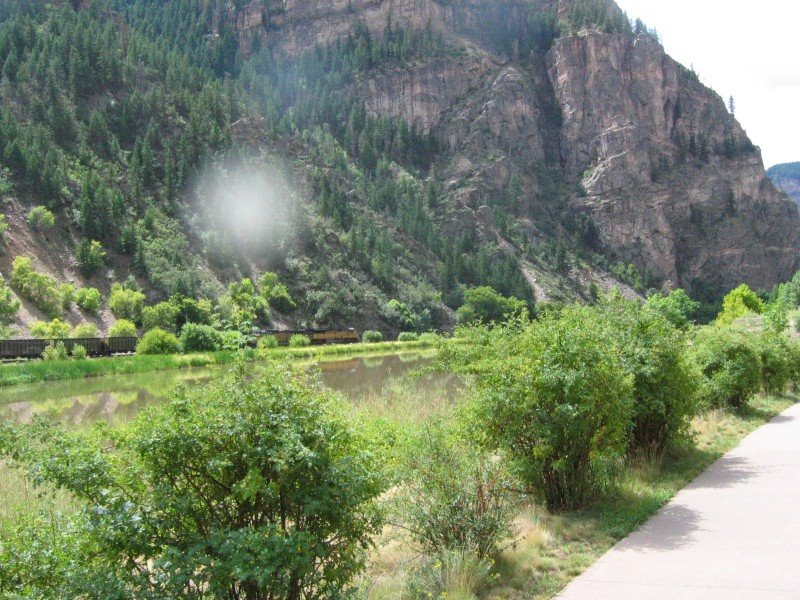
And for the benefit of my father-in-law, an old railroader with the former Denver and Rio Grande Western, the obligatory train-in-canyon shot. Sorry about the flare, I had a spot on my lens.

A good time was had by all. For those of you visiting Colorado, and not accustomed to the altitude, or even walking, rent a bike in Glenwood Springs and make this your first trip. You have control over how far and long you ride, and then you turn around and ride in the downstream direction (mostly downhill) for your return.

Sunday, August 27, 2006

Let it go

Mostly I have been posting pictures and talking about scenic beauty. This post falls into the category of "other topics" and there are no pictures. So you can skip over this one if you just want to see the scenery.

It took me a while to get to the point where I could write this post because at first I didn't quite understand my own reactions. With time, I think I understand, and perhaps some person who reads this might be helped.

Between the demands of the UAW and programs to guarantee financial security for the top management of my former company, a bankruptcy is ongoing. Quite frankly, I was and am still alarmed by the long term prospects for the company. Acting on my (still rational) fears, I elected to take a lump sum, which marks down my pension and my post retirement health care to about 50% of its promised value. I took a lump sum because the last step in bankruptcy is liquidation, which would take everyone's pension to a level that "is about enough to feed my cat" in my wife's terms.

I suppose I could be angry, and people have encouraged me to write to express my pain. But I'm not angry. And this is the part I didn't understand. I didn't understand it until I took a long drive to a church hike with a divorcee, where she expressed her continuing anger, bitterness, and resentment about the events surrounding and after her divorce. She is one unhappy person, who feels pain every waking moment of every day.

But she has a choice. Yes, she got shafted by her divorce. But that event is in the past and cannot be undone. But her continuing anger and pain makes it impossible for her to enjoy the good things around her. She is getting shafted AGAIN, and this time by her own hand. With this 2nd shaft job, she has a choice. She can LET IT GO, and get on with her life. Or she can continue to be the queen of pain.

The things that the UAW and top management did at my former company, were things that I couldn't influence. They will dance away with their bucks, and the salaried folk will be left holding whatever bag remains. I can hang on to my anger about what happened, and let it destroy any possibility of appreciating the good things around me, or I can let it go. I choose to let it go.

I will view with concern the downward spiral of events at my former company, only because I still have friends there. I might even join a class action suit, but I won't become emotionally invested in it. No, I won't be the guy in the bar who rails on and on about how he got screwed. I'm too busy hiking and skiing and working and making new friends.

Post script
If you still think that hanging on to anger is simple justice, isn't that what the Shias and Sunnis and Israelis and Palestinians are doing? You killed my friend, so I will kill your friend. And the cycle of killing and retribution will never end until there are no survivors. How just is that?

Sunday, August 20, 2006

Bear Creek, not for the weak or inattentive

About 100 miles south of Grand Junction, the town of Ouray is nestled in the San Juan mountains. Ouray is the small flat spot with stuctures in the center of the picture. The sign says "Little Switzerland" and having seen both, I agree, except the good thing is that it doesn't have the trams or trains or ski resorts of Switzerland. Ouray is mostly wild and unfiltered.

Ouray is surrounded by multiple peaks above treeline. You crank your eyes upward toward the peaks as you drive in to town and majestic music plays in your head, at least my head. Luckily, someone else was driving, so we didn't drive off the road. 2 miles south of Ouray is the trailhead for the hike up to Yellowjacket mine, on the Bear Creek trail. A good description can be found at:
http://www.ouraytrails.org/trails.html#bearcreek


This website says: "Not recommended as a first hike for people just getting up to this altitude, for those fearing steep dropoffs, or for those with venturesome children." Good advice. I'll illustrate the advice with this picture of the trail. Colorado gold miners pickaxed a narrow path along the face of granite cliffs so they could bring their stuff to the gold mines in this canyon. This brings up the obvious question, who is crazier, miners with gold fever who hiked this path, or the recreational hikers who do it for fun? One more piece of advice. Go early in the morning on a rainless day, it usually rains in the afternoon, and you don't want to be caught on this trail in the rain, as I was (wet slickrock and talus shale).

Sometimes the trail is close to Bear Creek and you see visions of rocky mountain spring water. By the way, this trail is on the other side of the continental divide from Coors, so this water never makes it into their beer.

And sometimes the trail is hundreds of feet above Bear Creek. I should have included my toes in this picture to give some idea of the depth of the canyon.

This picture posts sideways for reasons unknown to me. It is a picture of the sign at the Yellowjacket mine. I posted a question to the Blogger folks and maybe they can help me. You can see a faint hint of treeline up above and some iron mining junk at the base of the sign.

The trailhead south of Ouray is at 8400 feet. Yellowjacket mine is at 11,100 feet, just below treeline, and a climb of 2700 feet. I carried a light pack with just water, snacks, and a poncho, which I needed for the rainstorm on the way down. I have done some previous hikes, and my legs hurt on the way up, on the way down, and after the hike. When I mentioned my pain to the 60 year old woman who accompanied me on this hike (she wanted to go hiking again in a few days) she called me a "wuss". Hey! That's MISTER Wuss to you, pal :-)

Tuesday, August 15, 2006

Crag Crest, Grand Mesa

Just to the east of Grand Junction, there is a formation called Grand Mesa. Unlike the sandstone that surrounds the rest of Grand Junction, Grand Mesa is topped by a flat layer of slowly eroding volcanic rock. Grand Mesa is the large flat feature in the background of this picture. More information can be found at http://en.wikipedia.org/wiki/Grand_Mesa

There is a small reference to Halka Chronic at the bottom of the Wikipedia article. Her Roadside Geology series is interesting to those who are into that kind of stuff, like me. Dry and technical, but still highly recommended.
I went with a church(??!!) group to the highest point on Grand Mesa, on a hike called Crag Crest. The hike starts out at green meadows, forests, and lakes.

Trees and meadows are highly unusual for this part of the US, because it is a desert. Grand Mesa gets a large amount of snow and rain, and the elevation is above 10,000 feet, so it is alpine-cool. The top of Grand Mesa is something like an oasis of trees and lakes suspended in the sky.

As you hike higher, the trees give way to volcanic rock.

Further along the hike, we could see a swath of trees that had been blown down by strong winds. These trees had been growing for hundreds of years, yet they were taken out this year. Why? Coincidence? At this point I want to recommend a movie starring Weird Al Gore called "An Inconvenient Truth". The movie is about carbon dioxide and its effect on global warming. A few interesting factoids from the movie. The snows of Kilimanjaro, which have been present since before the dawn of man, will disappear by next year. Another one, ten of the hottest years on record have occurred in the last 14 years. Impossible to dismiss with random statistics and NOT a coincidence.

There are many hurricanes, but the killer ones travel through the Gulf of Mexico and pick up enormous energy from the warm waters of the Gulf. The Gulf is becoming warmer and warmer year by year. Killer hurricanes, blowdowns, and other violent weather will become more and more common as the atmosphere becomes warmer.

There is something we can do about this. My Pontiac Vibe gets over 30 honest miles to the gallon and it's not an expensive hybrid or a teeny 2 seater. If everyone moved to smaller vehicles, the largest carbon dioxide producer in the world (the US) would move back toward 1980ish levels, even though the miles driven increases every year. Just think, a cheaper vehicle, less money for gasoline, and saving the earth at the same time. What a deal!

This is a picture of the hike along the "crest" of Crag Crest. You might be able to see one of my hiking companions on the trail. She gives some idea of the width of the trail and the crest. Summer is the best time to hike this trail, because there are fewer rainy days and the temperature is in the pleasant 70's because of the altitude.

At the top of Crag Crest, you have a 360 degree view. In this picture, the line of green trees stops at the edge of the Mesa, and you can see the Bookcliffs to the north. The tiny flowers in the lower left corner are wild columbines, the state flower of Colorado.

The elevation change for this hike was about 800 feet, to get to an elevation of about 11,100 feet. 60+ year old women did this hike with me. You probably can do this hike, too. And if you look around, you might see the world in a slightly different way.